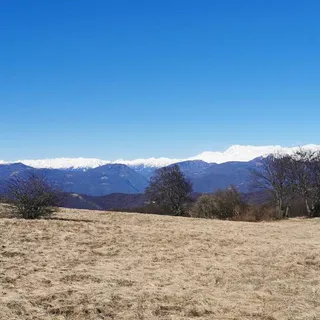


Plave (pri železnici) - Korada (General)
2 h 30 min




 Weather
 Nearest webcam

| Rating: | |
| Country: | Slovenia |
| Mountain range: | The Goriška, Notranjska, and Snežnik Mountain Ranges |
| Trailhead: | Plave (pri železnici) (100 m) |
| Destination: | Korada (812 m) |
| Trailhead latitude/longitude: | 46.044 / 13.5884 |
| Destination latitude/longitude: | 46.0649 / 13.5606 |
| Difficulty: | Easy marked route  |
| Recommended equipment: | Hiking poles Hiking shoes Water Snack |
From Tolmin, head toward Nova Gorica. In the village of Plave, turn right toward Dobrovo and cross the bridge. You’ll come to two intersections; at the first, keep to the right, and do the same at the second. Then continue to the concrete road branching off to the left, where you’ll turn. Drive to the next fork, where you’ll turn right; you’ll then see a parking lot on your right, where you can park.
Trail description:We walk back to the concrete road, but this time we begin climbing further up it. When the terrain levels out and we reach the houses, a road branches off to the right, which we take. We climb up to the church and go around it on the right. This leads us into the forest, where we take the left path and begin a longer climb. The path leads us to a major fork and joins a gravel road. Here, turn right and walk along the gravel road for a while, until a narrow path branches off to the left again; take this path and continue the ascent. The trail leads us back to the gravel road, which we rejoin. Here, we briefly emerge from the forest. We continue to the houses, where we turn left, cross a short meadow, and head back into the forest. Follow the path uphill to an asphalt road; join it, turn right, and continue along it for a short while until a narrow path branches off to the left again; follow this path as you continue the ascent. This path leads to a fork in a gravel road, where we turn left and follow the road until we reach another narrow path branching off to the left; we join this path and continue the ascent. When we emerge from the forest, the terrain levels out, and the trail leads us past a church to meadows, across which we walk to the summit of Korada. If we wish, we can extend our hike by a few more minutes to a nearby mountain hut.
Additional tips:No additional tips.